Saturday, January 28, 2006
The Blue Nile & the Tisisat Falls
The impression of many people I talked to before heading off to Ethiopia was that they thought it was a dry, desert-like country, and why would anyone ever want to go there. But in fact, there is a great deal of rainfall in Ethiopia, albeit mostly falling between the months of July and September. Much of this rain occurs in the highlands of Ethiopia, the area where we spent much of our time, and falls into the catchments of the Blue Nile River.
To say that the Blue Nile River (called the Abbai at it’s source) is a large river is somewhat of an understatement. It is roughly 4400km from its source to the Mediterranean Sea. According to some accounts, 90% of the water from the Nile in Egypt is sourced from the Blue Nile and its tributaries in the highlands of Ethiopia. The source of the river is reputedly in the southern corner of Lake Tana, slightly east of the city of Bahir Dar, though according to Alan Moorhead’s book, The Blue Nile (1972) there is an alternate theory (in fact described as an accepted belief more than an argument).
To say that the Blue Nile River (called the Abbai at it’s source) is a large river is somewhat of an understatement. It is roughly 4400km from its source to the Mediterranean Sea. According to some accounts, 90% of the water from the Nile in Egypt is sourced from the Blue Nile and its tributaries in the highlands of Ethiopia. The source of the river is reputedly in the southern corner of Lake Tana, slightly east of the city of Bahir Dar, though according to Alan Moorhead’s book, The Blue Nile (1972) there is an alternate theory (in fact described as an accepted belief more than an argument).
…that the river really rises in a swamp called Ghish Abbai, some seventy miles
away to the south. From this swamp the Little Abbai river courses down through
the Ethiopian plateau to the south west corner of the lake, and its waters are
said to proceed through the lake itself to the opening near Bahardar…1
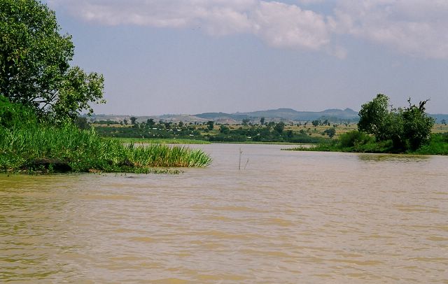
I don’t know if this is true or not but anyway, our boat trip on Lake Tana took us to the outlet from the lake known as the source of the Blue Nile. Like the lake, papyrus reeds bordered the edge of the river and locals worked by its banks collecting reeds and building canoes. The water still had the same silty hue as the lake. The flow from the lake was barely perceptible and a world apart from the torrent further downstream. But for the narrowing of the channel, we could still have been on the lake itself!
 We traveled about thirty or forty kilometers downstream by road to the first major landmark on the river after the source… the Tisisat (or Blue Nile) Falls. Once upon a time these falls were said to be spectacular.
…it is an extraordinary thing that they should be so little known, for they are,These days I would doubt that they can be compared with the Victoria Falls; since 2000 there has been a hydro scheme on the Blue Nile River, and the Tisisat Falls are robbed of some of the flow of water owing to the greater need for electricity production. With the slower flow, the microclimate around the base of the falls has also changed. The misty spray of water is gone, as is the small rainforest.
by some way, the grandest spectacle that either the Blue or the White Nile has
to offer; in all Africa they are only to be compared with the Victoria Falls on
the Zambezi.1
That said the falls are still pretty good…better than your average falls. They are still 45m high, and during the wet season when the dam is full, the water flow is quite fast and the falls are wider than when we saw them.
We also saw a few interesting things on the way to the falls… 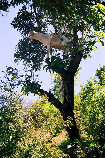
- Goats up a tree… maybe they got a better view up there? And one of the local kids was trying to get money from me after taking a photo of them stating that “Those goats belong to my family”!
- A bridge built in the 1600s by the Portuguese. This was another of the Da Gama family’s explorations (Vasco’s son this time). The bridge has stood the test of time and stands firmly crossing one of the offshoots from the Blue Nile hydro scheme.
- Blacksmith shop in one of the village huts. Being early in the trip we were very keen on taking photographs of anything “cultural”. We all paid the going rate of 1 Birr (about 12 US cents) per photograph and the blacksmith could have stopped work for the rest of the day (or week or month) after we left!
__________________________
1 Alan Moorhead, The Blue Nile, NEL, November 1972, pg 10-12
// posted by rachelle @ 4:17 PM 
![]()